How is Environmental Justice being evaluated near you?
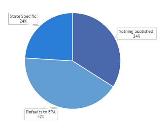
Following recent federal activity, environmental justice (EJ) requirements are being incorporated into legislation and regulations across the country. To date, over half of the 50 states have published a written commitment to environmental justice; however, many of these states default to federal programs, while only a subset of states have released state-specific EJ guidelines (e.g., California, Minnesota, New Jersey, etc.). A breakdown showing how states are addressing EJ guidelines is depicted below.
To keep pace with the rapidly evolving EJ climate, Roux is tracking each state’s specific EJ information; from published EJ commitments and policies to EJ community definitions and socioeconomic criteria, which enables us to efficiently evaluate state-specific activities and requirements. For example, definitions of EJ communities differ by state.
- Minority criteria: States most commonly define EJ communities based on minority status, though criteria vary. For example, Minnesota utilizes a cutoff of ≥ 50% of the people in a census tract identify as people of color, while Colorado utilizes a cutoff of 40%.
- Economic benchmarks: Many states also utilize economic benchmarks. For example, Oregon’s benchmark is “low income” where at least 30.9% of the population lives under 200% of the poverty level, while Minnesota considers a census tract to be an area of concern for EJ if at least 40% of people reported income less than 185% of the federal poverty level.
- Other criteria: A smaller subset of states include language (e.g., level of English language proficiency), educational attainment, and other criteria to define EJ communities. For example, several states including California and Minnesota consider tribal areas or lands under the control of federally-recognized Tribes as disadvantaged.
The differences don’t end there. Several states (e.g., California, Connecticut, New Jersey, and New York) have produced their own state-specific screening tools, in addition to the federal screening tools such as the Environmental Protection Agency’s EJScreen, the White House’s Climate and Economic Justice Screening Tool, and ATSDR’s Environmental Justice Index Explorer. These state-specific mapping tools rely on publicly available data sources for census block demographic information (such as the 2016-2020 American Community Survey 5-year Estimates), coupled with proxies for environmental exposure to different pollutants (e.g., diesel particulate matter, air toxics emissions, and proximity to hazardous waste facilities).
Screening of potential community impacts using these spatial tools needs to be performed carefully, with knowledge of the local community and site-specific conditions. For example, many tools highlight potential environmental exposures based solely on proximity to a certain type of facility, without regard for potential environmental transport (e.g., predominant wind direction, surface water flow, or direction of groundwater flow); known levels of contamination or lack of contamination; and/or history of known releases, violations, or remedial actions.
Roux’s team of environmental scientists, Geographic Information Systems (GIS) practitioners, and human health risk assessors have years of experience with these assessments. While it may seem simple to substitute a robust technical assessment for the output from various environmental, socioeconomic, and health datasets and screening tools being published by a spectrum of organizations, it is important to distinguish the limitations and caveats of these tools versus their appropriate uses. If you have questions about how these EJ tools work and are being handled in your area, please reach out below to discuss with one of Roux’s experts.